Vertical and Oblique Aerial Photography
| Aerial photographs are generally classified as being vertical or oblique. A vertical photograph is one which has been taken with the camera axis directed toward the ground as vertically as possible, while an oblique photograph is one which has been taken with the camera axis directed at an inclination to the ground. |  |
Vertical
This image is a vertical aerial photograph of the River Forth at Throsk, Stirlingshire, in 1988.
Vertical photographs are the most common type of aerial photograph for remote sensing and aerial survey purposes. They can be scaled, allowing objects and distances to be measured, aiding in their identification. When viewed in stereo, vertical photographs can give information about the height or the vertical characteristics of landmarks and buildings.
Vertical aerial photographs can provide very useful information, in conjunction with maps and other sources, when searching for unexploded ordnance or assessing property boundaries, for example.
|
 |
Oblique
This image is an oblique aerial photograph showing the River Forth at Throsk, Stirlingshire, nearly 50 years earlier. It shows almost the same area of land and water as the vertical image but is taken with the camera axis pointing to the north-east.
Oblique aerial photographs provide the viewer with an easily comprehensible image of a location and is useful for looking at foreground building frontages. Features in the background are often too small to be recognised or can be hidden behind buildings, however.
This type of image can be classified as a 'high oblique' which includes the horizon in the image, or a 'low oblique' which does not. The image to the right is an example of a 'low oblique'. |
 |
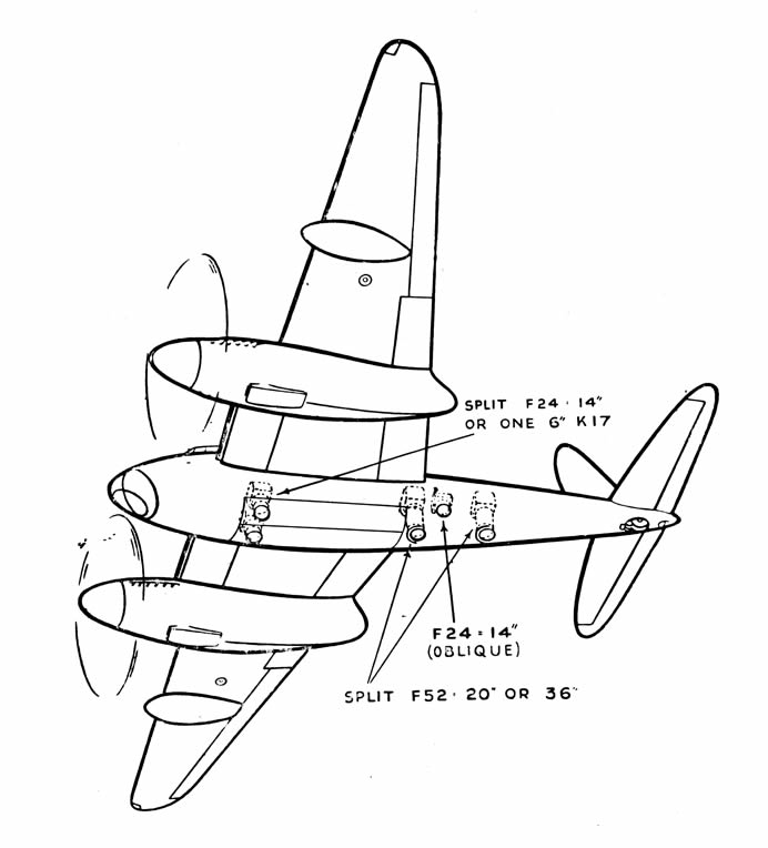
The image below shows some of the camera locations in the de Havilland Mosquito aircraft, widely used in the photographic reconnaissance role during the Second World War. This particular aircraft has four cameras mounted vertically, along with a port-facing oblique.