In 1775, when John Paul Jones, of Kirkbean, Kirkcudbrightshire, Scotland, was helping to found the United States Navy, the techniques of photography and the principles of manned flight had not yet been discovered. Jones could never have imagined that 190 years later, mirroring his own forays to Scottish waters, the same force would launch a jet-powered aircraft, capable of flying from the deck of a ship, to take aerial photographs of his homeland. These photographs now form the collection of US Navy Aerial Photographs held within NCAP. The areas covered are the entire North-East Highland coastline, from Inverness to Duncansby Head; the Solway Firth from Isle of Whithorn to Barrow-in-Furness; plus Stranraer and Leith. Some examples of the images in the collection are featured below.
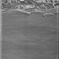
Granton, Edinburgh
Granton gasworks, photographed on 11 July 1966. This extensive site was built in the early 20th Century to serve Edinburgh and Leith, and was finally demolished in 2003. The Pilton housing estate can be seen under construction in the background.
|
 |
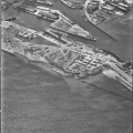
Leith, Edinburgh
The port of Leith undergoing reclamation and expansion on 11 July 1966. In the foreground is a 19th-century Martello tower; this coastal defence work was built on offshore rocks and has been incorporated into the extended breakwater. Victoria Quay, in the middle distance, has since been infilled and is now the site of the Scottish Executive.
|
 |
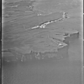
Duncansby Head
View west over the cliffs of Duncansby Head, on 26 July 1963, with the lighthouse and Royal Observer Corps underground warning and monitoring post visible on the promontory. A civilian Handley Page Herald aircraft can be seen in the middle distance, inbound for Wick.
|
 |
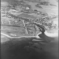
Brora
This image shows the Sutherland village of Brora on 26 July 1963, with colliery buildings and winding headgear visible at centre left. In 1969, an underground fire forced the fire brigade to flood part of this coal mine. The remaining shaft closed in 1975.
|
 |
Wig Bay
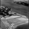
Aircraft hardstandings and hut-bases were all that remained of the former Royal Air Force flying-boat base at The Wig, Loch Ryan, when photographed on 13 July 1964. During the Second World War, this location was home to Sunderland flying-boats of RAF Coastal Command.
|
 |
Stranraer
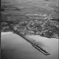
The port of Stranraer, taken on 3 June 1964. Visible extending out from the shore is a rail-served pier used by ferries to Northern Ireland.
|
 |
Ardwall Island
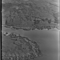
Photographed on 26 July 1963, this high-oblique of Ardwall Island, in the Solway Firth, illustrates the geological value of aerial photography. Visible in this photograph are several tight synclines and anticlines, characteristic of the geology of the Southern Uplands. Such units can be difficult to map on the ground and aerial photographs can assist the initial geological reconnaissance of an area.
|
 |
Rigfoot
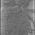
The Rigfoot ammunition depot near Annan is depicted in this image, taken on 26 July 1963. Visible are the dispersed storage bunkers, within their protective blast walls, interconnected by a narrow-gauge railway. One of the ammunition trains can be seen entering a bunker at centre left.
|
 |
Sellafield
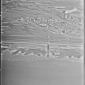
Windscale (now Sellafield) nuclear processing site, photographed on 26 July 1963. Built in 1947 to produce plutonium for use in British nuclear weapons, Windscale has also been used to develop electricity-producing reactors and to process spent nuclear fuel.
|
 |
Solway Viaduct (north abutment)
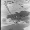
This image shows the northern end of the Solway Viaduct, built in 1869 to facilitate the transportation of iron ore from West Cumberland to Scotland. The viaduct was of cast iron construction and was used until 1921. It was demolished in 1934.
|
 |
Solway Viaduct (south abutment)
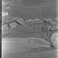
This image shows the southern end of the Solway Viaduct, with the disused Solway Junction Railway line continuing into the distance. The viaduct had 193 spans and its construction altered the river currents to such an extent that the harbour at Port Carlisle, to the east, silted-up and lost trade.
|
 |
Whitehaven
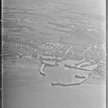
An example of a planned Georgian town, the port of Whitehaven was a major 18th century coal trading centre. It is thought that some of the US Navy photography held by NCAP was flown to locate suitable beaches for beach landing training by US amphibious forces. In 1778, when preparing for his amphibious raids on Whitehaven and St Mary’s Isle, Kirkcudbright, John Paul Jones would have relished such intelligence.
|
 |
Walney Island
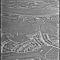
An example of a Second World War coastal gun emplacement, with its attendant searchlight position and observation tower, at Walney Island, Cumbria, on 26 July 1963. Two empty gun-emplacements are visible, with their attendant servicing and partly-demolished accommodation buildings to the rear.
|
 |
Barrow-in-Furness
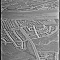
This image captures the construction of a nuclear submarine, on the beach at Barrow-in-Furness on 26 July 1963, before the advent of reconnaissance satellites forced such vessels to be built under cover. The vessel under construction is HMS Vanguard, which was laid-down at Barrow in January 1962 and launched in December 1963. In 1967 she set a Royal Navy record by sailing 12,000 miles submerged, from Singapore to the UK, in 28 days. She served in the Falklands War in 1982 and was decommissioned following engine trouble in 1994.
|
 |
Service in Vietnam
The photographs in this collection were taken between 26 July 1963 and 11 July 1966 by the US Navy’s VAP-62 (Heavy Photographic Squadron), flying the Douglas RA-3B Skywarrior, the photographic reconnaissance version of the A-3 bomber. This aircraft equipped VAP-62 from late 1959 until 15 October 1969, when the unit was disbanded. During its decade of service, the unit operated from its home base of Naval Air Station Jacksonville, Florida, as well as various aircraft carriers and shore bases around the world.
Many of VAP-62s Skywarriors saw combat during the first 5 years of the Vietnam war, while attached to a sister squadron, VAP-61. Tasked with the reconnaissance of roads and tracks in North Vietnam, during night operations the unit used infra-red sensors to locate enemy transport movements, illuminating them with parachute flares for subsequent attacks by other aircraft. The RA-3B was chosen for this role because of its ability to fly at a sustained 360 knots at an altitude of 1500 feet, thereby allowing it to approach targets quickly, retain some element of surprise and increase aircraft survivability.
Versatile Platform
First introduced in 1956, the Skywarrior was nicknamed ‘The Whale’ because of its great size for a carrier-borne aircraft, an attribute which enabled it to serve in a wide variety of roles, from nuclear bomber to air-refuelling tanker and electronic signals gatherer. The RA-3B had a fully pressurised fuselage, housing a flight crew of four (pilot, co-pilot, photo-navigator and photo-technician) and up to 12 oblique and vertical cameras. It was capable of taking photographs by day and night, with a number of photo-flash bombs held in a small bay behind the cabin for target illumination at night. Electronic Warfare versions of the Skywarrior continued to serve with the US Navy until 1991, with several seeing service during the first Gulf War.
RA-3 banking to show its camera ports.
RA-3 behind an array of aerial cameras.
Survey Projects
During its period of service, detachments from VAP-62 were sent to undertake a variety of mapping and survey projects in northern Europe, the Mediterranean, the Middle East, Central America, Iceland, Canada and the United States. Several special assignments were carried out, including photographing the launch of early manned satellites, a cartographic survey of the Great Lakes region, photographic surveys of flood damage, and tracking and seeding of hurricanes. During the 1963-1966 period, VAP-62 occasionally deployed to Rota, Spain, and then undertook detachments to a number of European bases, including Prestwick, Scotland.


