The Directorate of Overseas Surveys (DOS)
The Directorate of Overseas Surveys
NCAP became the official custodian of 1.5 million aerial photographs created for the Directorate of Overseas Surveys (DOS) in late 2012. Established after the Second World War, DOS was responsible for mapping those parts of the British Empire, and latterly countries throughout the Commonwealth, which had no survey capability of their own. DOS contracted wide ranging aerial surveys of each country, to provide a basis for cartography. In turn, the cartography and aerial images helped to inform the development and administration of each country.
Flown during peacetime, DOS aerial photography covers large parts of Africa, the Far East, and the islands of the Caribbean Sea, Atlantic and Pacific Oceans. The photography provides a unique historical perspective and is in effect a 'Doomsday Book' of the Commonwealth. The 3D aerial photography in the DOS Collection records the changing urban and rural landscape of large parts of the Commonwealth throughout the second half of the 20th century.
| Alastair Macdonald reflects on his work in Africa, as a surveyor with DOS. |
Mapping the World
The DOS was founded by the Colonial Office in 1946 and it existed for 38 years before being merged with the Ordnance Survey in 1984. During its years of service, the Directorate's officers, based in suburban Tolworth in south-west London, were charged with two key tasks:
- Provide national geodetic frameworks throughout the British Empire that would contribute to understanding the size and shape of the earth and constitute the basis for accurate mapping;
- Produce mapping using modern methods, based on aerial photography
When the Colonies moved to independence, the remit of DOS was expanded to include countries within and outwith the Commonwealth, which meant the Directorate's surveyors ultimately surveyed fifty-five countries around the world. These included countries in Australasia and the Far East, the Indian Subcontinent, Middle East, Africa, Caribbean, South America, British Antarctic Territory and islands in the Pacific, Atlantic and Indian Oceans and the Mediterranean Sea. Aerial photography of each country was contracted from a variety of commercial survey firms and exploited by staff at Tolworth and in the field.
Spanning 50 years, the DOS Collection of aerial photography allows the comparison of images taken at different dates. For researchers, this allows changes in the natural and human environments to be studied in detail.
Big Bend, Swaziland
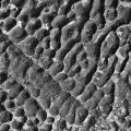
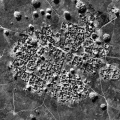
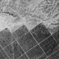
From left to right, these images of Big Bend, Swaziland, were taken in 1947, 1961 and 1971.
The images illustrate the development of road communications, agricultural practices and human habitation around this meander in the River Lusutfu. |
 |
Montserrat
In July 1995, the Soufriere Hills volcano in southern Montserrat erupted after centuries of dormancy. The principal town, Plymouth, was destroyed by mudflows and the southern part of the island was abandoned. The volcano continues to periodically erupt.
These images from 1982 (left) and 1999 (right) illustrate the burial of Plymouth beneath volcanic mud and ash. The image on the right is a false colour infra-red image, which shows healthy vegetation in shades of bright red. |
 |
DOS on Record
The work of DOS in the air, and on the ground, was recorded in colour for a 1969 documentary film, Framework for the Future, now held by the British Film Institute. The work of this unique organisation, its social history and accounts of the land surveyors interaction with local people, was the subject of a 1996 publication, Mapping the World, by Alistair Macdonald. In 2014, the collection provided the basis for Sightlines, a short film on its legacy, presented to celebrate the Glasgow 2014 Commonwealth Games.
|
A tellurometer measurement being made from the standard 20-foot observing tower on a beach in Sarawak. Stores are being landed from a 35-foot outboard engined prahu, while Melanau fishermen look on from the background.
The tellurometer uses microwaves to electronically measure distances to other survey stations. It has a range of up to 70km, can penetrate haze and dust and is resistant to extremes of temperature, all of which made it an ideal survey instrument for DOS. |
 |
|
Theodolite and heliograph at a survey station in the Fali Hills of northern Nigeria. Access to this station was by foot only; a three-day trek from the nearest road at Baissa.
The parasol was standard-issue equipment to DOS survey parties and served to keep both instrument and operator shaded from the sun. |
 |
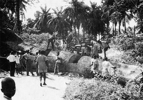
| The cross-country progress of survey teams working in undeveloped areas could be slow. Here, a tree has blocked the road between Dunlop and Calabar in eastern Nigeria. Surveyors and local people, working with hand-axes, took two days to re-open the road. |  |
| DOS surveyors were active in training the staff of survey departments in their own territories. Here, a surveyor demonstrates the operation of the MRA 101 tellurometer to members of the Survey Department of Tonga. DOS staff engaged in photogrammetry and cartographic processes at headquarters in Tolworth were also accustomed to training survey staff from around the world. |  |
After merging into the Ordnance Survey in 1984, DOS became known as the Overseas Surveys Directorate. In 1991, following completion of the last significant aid-funded mapping projects, its name changed one last time, to Ordnance Survey International, and its main activity became consultancy, primarily in eastern Europe. Following closure in 2001, responsibility for the records created during its years of existence was passed to The National Archives. The following year, the 1st Print Library, definitive finding aids and air photo mosaic collection were transferred to the British Empire and Commonwealth Museum, Bristol, and then in 2012 to NCAP.


